Remnants of Hurricane Beryl bring heavy rains to Michigan

The remnants of Hurricane Beryl are expected to move across southern Michigan on Wednesday, bringing the threat of excessive rainfall to much of the Lower Peninsula.
“Attention is focused on the remnants of Beryl on Tuesday night and Wednesday night,” the Detroit/Pontiac NWS said in its daily forecast discussion on Monday, July 8. “The 00z models continue to converge on a solution that will bring an extended period of rain to the region, with some fairly heavy precipitation.”
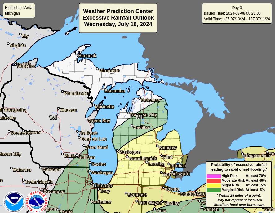
The NWS Weather Prediction Center has identified a slight risk (at least 15%) of excessive precipitation for much of Michigan’s Lower Peninsula due to the remnants of Beryl. Detroit, Grand Rapids, Midland and Bad Axe are in the risk zone. The northern part of the Lower Peninsula, stretching from Big Rapids to Alpena, is at a slight risk (at least 5%) of excessive precipitation.
“There is still quite a bit of spread in the forecasts regarding the development/trajectory of the post-tropical beryl and exactly how this upper-atmosphere energy will be ejected into the Great Lakes/Midwest overall low,” the NWS Weather Prediction Center said in its day three forecast discussion. “The inflow of tropical moisture should bring the highest precipitation water anomalies to the lower Great Lakes and Northeast during this time period.”
The Excessive Rainfall Outlook (ERO) is the Weather Prediction Center’s (WPC) forecast of the probability that precipitation will exceed the flash flood guideline (FFG) by one point within 40 kilometers (25 miles).
Beryl’s center is currently expected to move through the northern Ohio Valley into the western Lake Erie region by Wednesday night.
“At this time, it appears that the risk of a fairly broad swath of over 2 inches of rain across parts of the region is becoming increasingly likely given the consensus forecast for Beryl in this package,” the Detroit/Pontiac NWS said. “Unless this basic forecast changes too much, headlines will most likely be needed to indicate the flooding potential.”


